May 23, 2016
Makeover Monday: The Militarization of the Middle East in a Post-9/11 World

After an epic week 20 for Makeover Monday, I had great expectations for this week. Another great data set, this time looking at global arms imports and exports. But dang it was tough! I really struggled this week making something I was happy with. In the end, time is up and I learned a lot.
Let’s start by looking back at the original visualisation.

What works well?
- The colors clearly distinguish imports and exports.
- The labels provide the needed context.
- Nice small line charts for Europe and the Middle East along with an indicator for the rate of change.
What could be improved?
- The title of the article doesn’t match the chart.
- It’s hard to compare countries.
- Why were the countries that are shown selected? Are they the top N?
- Why is the timeframe 2011-2015? That seems a bit arbitrary.
- Why are there only sparklines for Europe and the Middle East?
- The lower section with the flags has nothing to do with the map.
- In the lower section, why don’t UAE and China show awaiting delivery? It should be consistent.
- Is there a better story that can be told? The data goes back to 1950 after all.
I decided to focus on the title of the article: “The Militarization of the Middle East”. And I focused even farther by looking at the post-9/11 era from 2002-2015. America initiated a war with the Middle East. I wanted to know how that impacted the import of arms to the region.
Once again this was a week of iterations. I started with this small multiple map view, but didn’t think it showed the change through the years very well.
 |
| Click the image for the interactive version |
I then looked at a slope graph comparing the % of total arms imported in the region by country in 2002 compared to 2015. This definitely shows the rate of change better, but I lose the context of the years in between.
 |
| Click the image for the interactive version |
Maybe a DNA chart will work better than the slope graph? Not really, it just flattens it out.
 |
| Click the image for the interactive version |
I was getting frustrated by this point, so I decided to take the opportunity to learn a new technique. I read Matt Chamber’s blog post recently on how to build ranked bump charts and thought this would make a great use case for this type of chart. In this view, I can see how a country moves year by year in the ranking of arms imported into the Middle East. I really like being able to click on a country and see it highlighted.
What the bump chart loses, though, is the context of the overall value of the arms imported. So to take care of that, I included the sparkling which also updates when you click or tap on a country. In the end, I’m satisfied and I learned something new. That’s a bit of what Makeover Monday is about.
October 9, 2009
Afghanistan Troop Deployments
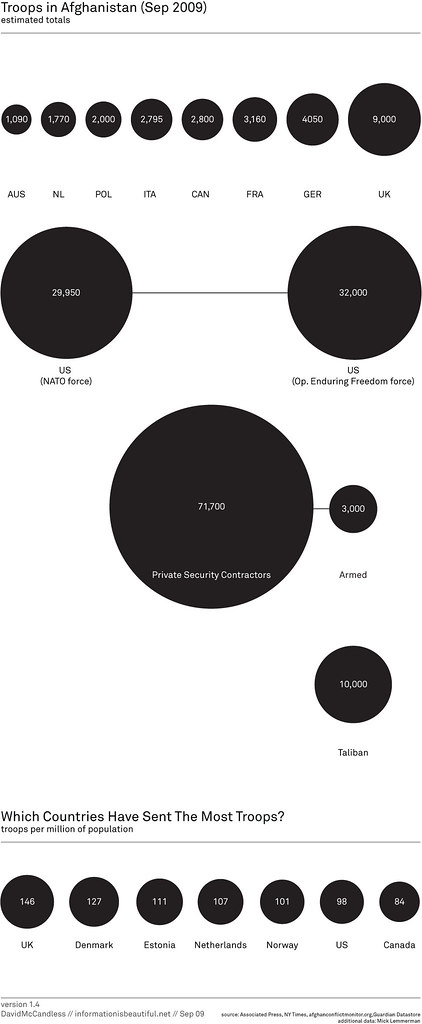
The first message that the bubbles are trying to communicate is simply the number of troops deployed.
I can see why he has the bubbles across the top; they're in a neat ascending order, but then the US is show below all of the other countries? Why aren't they all arranged together?
Also, what is the purpose of having all of the other types of "troops" on the chart? Finally, there is one pretty big issue with the data; where are all of the other countries that have sent troops?
Bubbles are a poor method of showing relative size. A simple bar chart works much better. Unlike the author, I have included "all other" countries.

The second message, which I cannot make heads or tails of, is the number of troops per million of the population. What is the purpose of this data and what insight can you possibly gain from it?
When I first saw this chart, I immediately tried to connect the bubbles at the top to the bubbles at the bottom, but it's impossible.
The title of the second chart is "Which countries have sent the most troops?" Ok, one more time, how could anyone possibly answer that question based on the troops per million of the population?
When I saw the question, I immediately though of a bar chart showing the percent of the total troops that each country has sent. I created this visualization below and added color to emphasize those countries that have more skin in the game.
From my visualization, you can see that the US has sent about 47% of the troops. In the bubble chart, I see the number 98. Which one do you think answers the question more appropriately?

If you really want to get sick, check out the rest of the author's bubble charts on this topic. I don't get the fascination with the bubbles...
* Data courtesy of The Guardian DataBlog
October 1, 2009
Pop the Afghanistan War Bubbles
The image below caught my eye. It's from a Flickr pool for the Guardian datablog.

The author's says "Latest military casualty figures in proportion to each force's troop numbers. I think this gives a clearer sense of which armies are taking the most flak."
Ok, I get the intent, but why the bubbles? Doesn't a simple bar chart provide a much simpler method for communicating the data?

Here's what I see in the data: the US provides the bulk of the forces, but loses the fewest casualties as a percentage of the total force. It's known across the world that the US military is one of the most prepared, so this shouldn't surprise anyone. I don't see any enlightening information in the author's analysis, other than simply giving us a pretty report.